

Every rider
Every station
One map
Confusion, wasted time, and inaccessible trips. A station without a map is a recipe for frustrated riders.
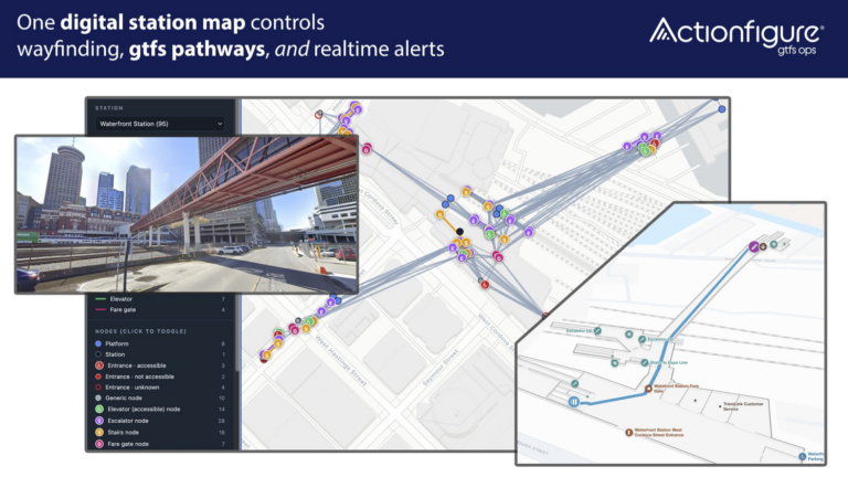
Actionfigure® Station Mapper quickly and easily turns the station floor plans you already have into both a rider-facing digital map and validated GTFS-Pathways data.
Finally, trip planners, Google Maps, Apple Maps, your agency’s app, and your service alerts all tell riders the same truth.
Station Mapper brings GTFS Pathways to your entire network
Riders can't plan a trip through a station they can't see.
Most trip planners stop at the station door. They don’t know which entrance is step-free, how far the platform is from the fare gates, or what to do when the elevator is out. So riders guess, accessible trips get abandoned, and your contact center and station staff answer the same questions all day.
The solution is one digital map of the station that riders, apps, and your staff can use.
One Digital Map does Four Jobs
Actionfigure is the first to bring transit data and indoor mapping together on a single digital station map. Build it once, and it:
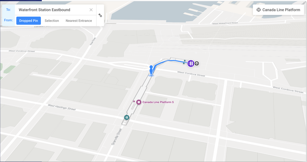
- Guides riders. Turn-by-turn directions from street to platform, with accessible routing, on your website, your app, or kiosks. Blue-dot navigation is supported when station infrastructure exists.
- Feeds trip planners. It exports validated GTFS-Pathways data, so apps like Google Maps, Apple Maps and Transit app can show entrances, step-free routes, real transfer times, and turn-by-turn wayfinding directions.
- Tells riders what’s broken. Mark an elevator out of service and the change flows to your maps and pathways data.
- Runs your stations. The same map becomes a digital twin for operations, incidents, maintenance and security.
You don’t need GTFS expertise; anyone who can read a map can use Station Mapper. Our GTFS Ops team handles the technical lift.
Accessibility
When the elevator is out, riders need a plan, not a warning. For riders who use wheelchairs, strollers, walkers or luggage, or who are blind or have low vision, “accessible station” isn’t enough. They need to know which entrance to use, where the elevator is, and what to do when it’s down.
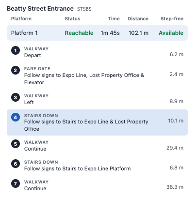
- Step-free routes from every entrance to every platform, with distance and travel time.
- Real-time elevator and escalator status. Update it from the map interface or connect an equipment feed. Out-of-service equipment is automatically left out of pathways data and shown in alerts.
- Directions that match your wayfinding signs, using the entrance and platform names riders actually see.
- Identify gaps before riders experience them. Station quality checks flag entrances with no step-free route.

In Vancouver, Station Mapper mapped Waterfront station complex consisting of 100,000 square feet, 7 levels, 9 entrances, and 3 operators.
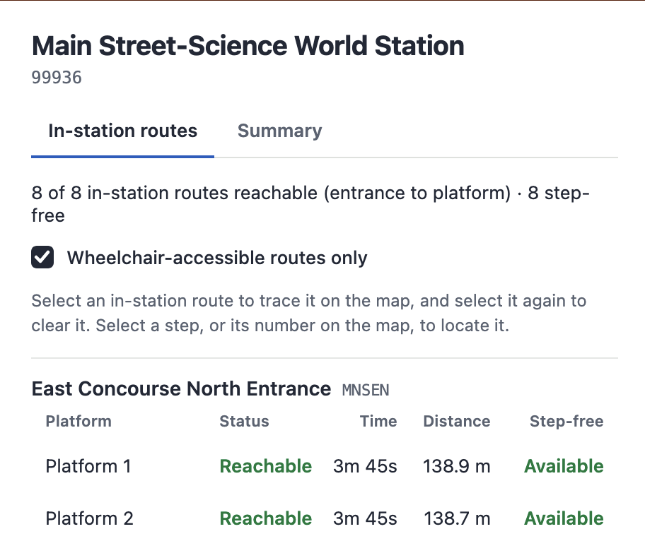
At Main Street–Science World station, riders now see that 8 of 8 entrance-to-platform routes are reachable, and 8 are step-free. Station Mapper even calculates and shows time and distance for each.
How it works
From station plans to published pathways, in three steps:
1. Start with what you have. Station plans, engineering drawings or CAD files. No LiDAR scanning or lengthy on-site survey is required. AI-assisted tools trace the plan, and our data specialists finish and check the result.
2. Build and validate. We convert the map to GTFS-Pathways and check it at every stage: MobilityData’s GTFS Validator, then end-to-end routing tests in OpenTripPlanner 2 for turn-by-turn directions, distances and step-free access. In our one-of-a-kind Pathways Viewer, you can see each route, time and distance.
3. Publish everywhere. Export GTFS Pathways (including levels and stops) to your trip planners. Publish maps in IMDF (Indoor Mapping Data Format) so Google Maps and Apple Maps can show your stations as indoor maps. Embed the interactive map on your website and in your app. (add hook to Journey)
GTFS-pathways and beyond
Start with pathways. Grow into a full station experience. The same map supports:
- Wayfinding on every screen. Websites and apps with real-time Journey trip planner, kiosk and QR code on station signage and TransitScreen digital signage displays.
- Station analytics. Where riders search, where they go and where they get stuck, to inform staffing, signage and retail placement.
- Live service information on the map. Alerts, equipment status and platform changes in context.
- Retail and amenity directories that stay current through content sync.
- Operations and safety views for maintenance, security and emergency teams: incidents, patrol scans and equipment, mapped.
- Custom apps. Use mapping SDKs to build the experience into your own app.
Why Actionfigure GTFS Ops
We’re more than just a mapping tool or consultant – we bring you global data experience operating the largest transit data platform, and creating transit data products at global scale.
- Largest transportation database. 45 countries, 3,000+ data sources, 25,000+ providers and 68,000+ routes tracked.
- GTFS experts since 2014. Build and maintain GTFS for agencies as a managed service.
- Tested in real-time and trip-planning applications. Our global OpenTripPlanner and OneBusAway deployments mean your station data is tested where it will be used
- We’re your solution partner, from station data to trip planning to rider-facing screens.

Tony Hudgins
SVP, Partnerships & Strategy
Hi, I’m Tony Hudgins, Senior VP of Partnerships and Strategy at Actionfigure.
I’d love to hear what you’re looking to achieve. No script, no pressure, just a real conversation.